




Ukraine has exposed a gap in Europe’s defenses that cannot be filled by simply adding more anti-aircraft batteries: the need for early warning from space.
An infrared satellite can detect the hot exhaust plume of a ballistic missile’s engine—or the signature of a massive launch—well before the target appears on the ground-based radar systems of the country under threat. These extra minutes are critical: they improve the time available to warn the population, protect airfields, and allow sensors to be directed toward the correct sector.
In this area, Europe remains heavily dependent on American data. However, France and Germany have agreed to establish the JEWEL initiative, while the European program ODIN’S EYE is developing the relevant technologies and architecture.
The ambition is significant, but the timeline places initial European capability in the early 2030s, with a French wide-field geostationary sensor expected around 2035.
What does SBIRS actually do?
The American Space-Based Infrared System comprises six infrared surveillance satellites in geosynchronous orbit, four sensors mounted on other satellites in elliptical orbits, and a ground segment for signal analysis.
The geosynchronous sensors remain continuously positioned over a large portion of the Earth and feature both a continuous scanning mode and a “step-staring” capability, which focuses attention on specific, selected areas.
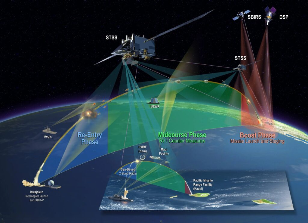
The system provides more than just launch warnings. It supports missile defense, battlefield awareness, and technical intelligence regarding missile behavior.
The initial alert from an infrared sensor includes the time, geographic region, and an preliminary trajectory estimate.
This is not always sufficient for firing an interceptor missile. Ground-based or sea-based radars must detect the target, refine the trajectory solution, and estimate the likely point of impact.
Space-based assets gain time and cue the sensors; the ground network then translates this warning into a defensive solution.
Geosynchronous orbit offers continuous coverage of a vast area, but it is located at a great distance from Earth. The sensor and its processing systems must be capable of distinguishing the thermal signature of a launch from clouds, fires, industrial sources, and reflections.
Lower orbits can provide different resolution and viewing geometry; however, they only pass over a given area for a limited duration and require a higher density of sensors—that is, a larger number of satellites.
A resilient architecture combines orbits and sensors that offer complementary advantages.
The warning chain consists of successive levels of certainty. The initial message indicates that a potential event has occurred, directing the attention of the networks toward it.
Subsequent measurements confirm the launch, estimate the trajectory type, and narrow down the area at risk. Updates must be provided iteratively, with refinements made as the analysis of the ballistic weapon’s trajectory improves.
The speed at which information is disseminated is just as critical as sensor sensitivity. Satellite reception, data transmission, automated detection, human verification, and delivery to the end-user all consume precious seconds.
In the case of a short- or medium-range ballistic threat, these seconds can determine whether a radar system has enough time to orient itself toward the correct sector, and whether civil protection authorities can issue an effective warning.
Operational specifications must define the required timeframe from the moment of launch to the point of action by the end-user.

What do we know and what do we not know about Ukraine?
The United States maintains a “Shared Early Warning” mechanism, governed by bilateral agreements, to transmit data on missile events to its partners in near real-time.
However, there is no public information regarding the specific data stream Ukraine receives concerning Russian missile launches—such as the latency involved or the categories of targets covered. The operational principle, nonetheless, is clear: early warning is only valuable if it reaches command centers and operational units quickly enough to influence their actions.
The same applies to civil protection. A blanket, nationwide alert stating that an “attack is imminent”—without specifying which area is at risk—exhausts the population and cripples the economy.
Consequently, the success of an early warning system is measured not only by the number of successful interceptions but also by the reduction in unnecessary disruptions to economic and social activity.
Furthermore, classification protocols can limit practical utility. The provider of the warning data (in this case, the U.S.) seeks to protect sensitive information regarding the precision and capabilities of its sensors, while the user (in this example, Ukraine) requires sufficient data to determine how to intercept an incoming ballistic missile.
Thus, a proper service can transmit a standardized message containing the time, region, direction, potential type of threat, and degree of certainty, without revealing sensitive satellite parameters. The exchange agreement must specify in advance who receives what, and via which network.
Training the recipients is part of the system. An air defense officer, an airfield commander, and a civil protection authority each require a different format of the same warning.
The former must orient sensors and ready weapons for the incoming threat, while the latter needs a clear geographic zone and a specific time window to alert the local population to seek shelter.
The common data source must generate targeted actions and avoid the issuance of multiple, conflicting messages.
JEWEL and ODIN’S EYE: The European Response
The Franco-German JEWEL agreement envisions a combination of space-based infrared sensors, ground-based radars, and a command-and-control system.
France and Germany are pursuing compatible geostationary satellites and a common architecture, aiming for Europe to develop a sovereign capability while simultaneously increasing its contribution to NATO.
Funded by the European Defence Fund, the ODIN’S EYE project develops technologies for space-based early warning and brings together industrial players from multiple nations. The primary challenge extends beyond the infrared sensor itself.
It encompasses secure data processing, the filtering of false alarms, rapid dissemination (within seconds), and integration with national air defense systems—which often rely on disparate networks and security classification levels.
A European solution requires a clear governance framework. It must be established who identifies an event, who authorizes the dissemination of information, which nation takes priority in the event of multiple simultaneous launches, and how the service is maintained during political disagreements or cyberattacks.
Technical autonomy holds limited value if the decision-making process introduces delays. The rules of use and the chain of responsibility must be designed in conjunction with the constellation.

One or two geostationary satellites do not provide global coverage or full resilience. What is required are overlapping fields of view, ground stations, redundancy, protection against cyberattacks, and a contingency plan for the event of a satellite loss.
Europe must also link the program to long-range radar and to the battery units that will carry out the interception.
